
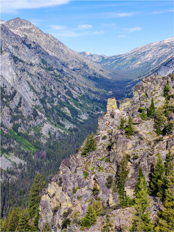
Some places are best experienced vertically. The rugged Mallard-Larkins Roadless Area is one.
The Mallard-Larkins Roadless Area is a steep and wild area between the St. Joe and North Fork of the Clearwater rivers.
Here’s one example of the area’s exuberant inclines: the distance between the North Fork of the Clearwater River at Aquarius Campground to the top of Black Mountain is just four miles as the crow flies, but a gain of over one mile in elevation.
In that mile are several distinct habitats of mesic forests, stunning views, and remarkable solitude.
At the bottom of the North Fork Canyon, just 1,700 feet above sea level, the Aquarius Research Natural Area protects several examples of coastal-disjunct plants that have survived here since the last ice age. These include populations of red alder, sierra wood fern, Pacific yew, and banks monkeyflower. Here, underneath mossy red cedars, its easy to think you are on the Olympic Peninsula.
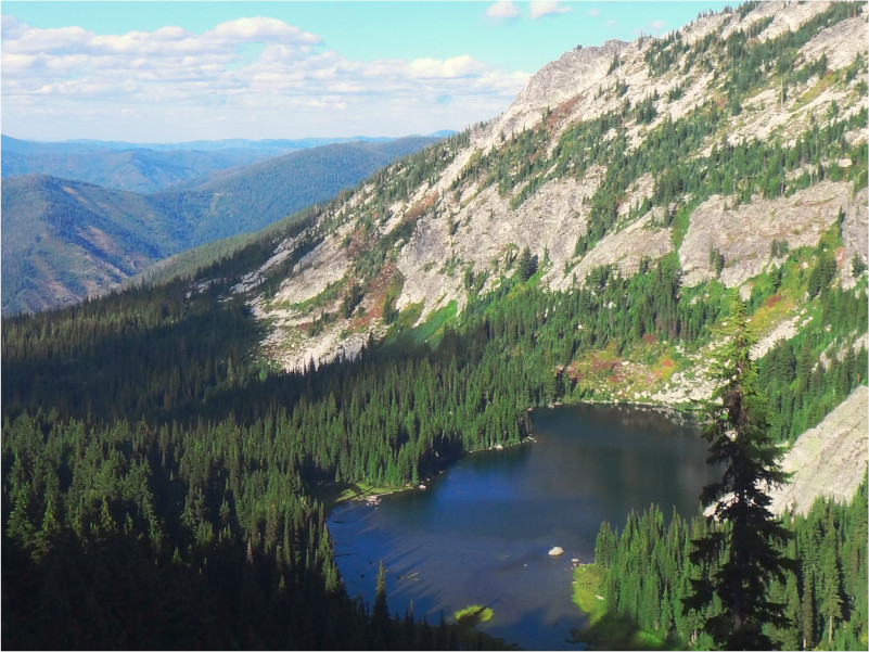
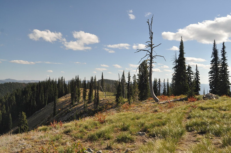
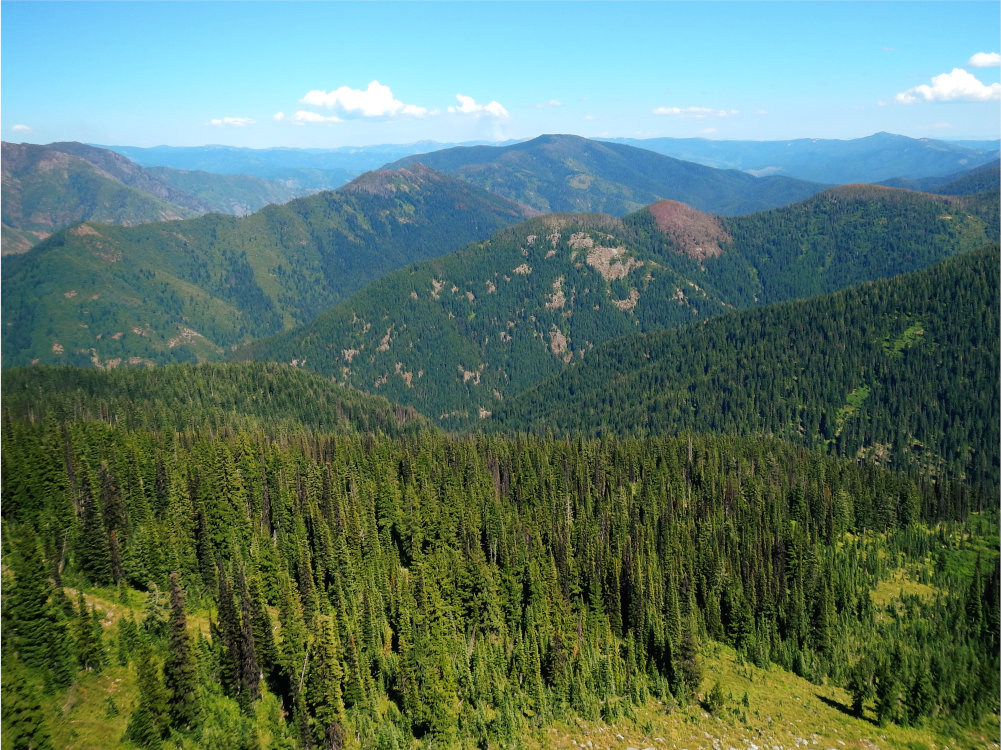
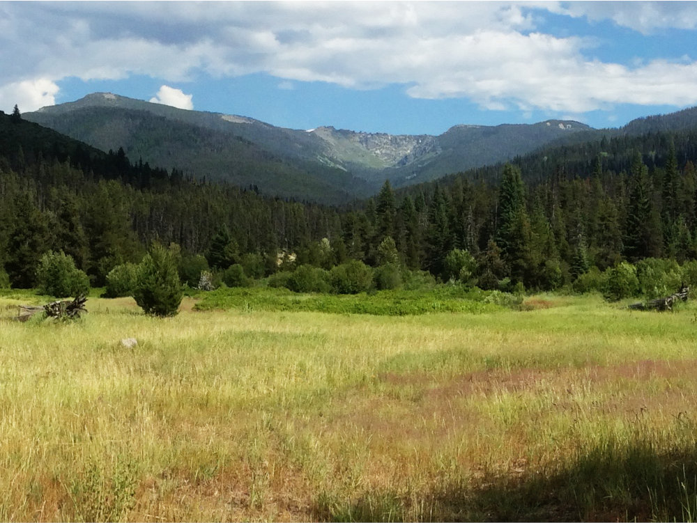
Further up is a different story. There are nine major peaks over 6,500 feet, rocky outposts above glacial cirques and alpine lakes. There are 38 named lakes in the area that lure visitors to their shores every summer.
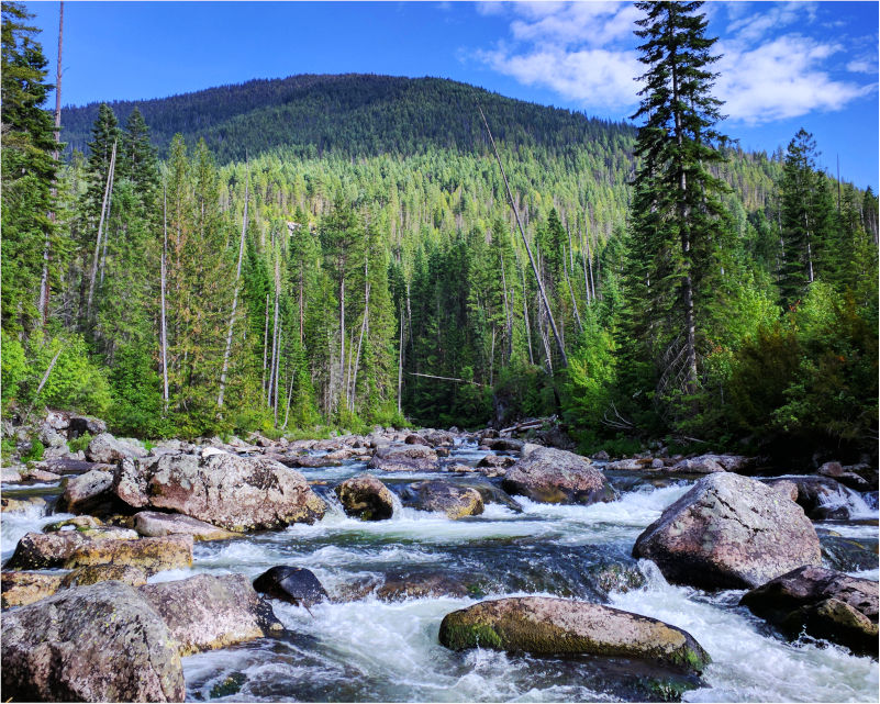
Flowing through or on the boundary of the area are parts of three major river systems: the St. Joe, the Little North Fork of the Clearwater, and the main North Fork of the Clearwater, along with numerous fast-moving and crystal-clear streams, both large and small.
Management of this area is split between the Idaho Panhandle (IPNF) and Nez Perce-Clearwater National Forests (NPCNF). The 2025 NPCNF forest plan recommends most of the southern portion of the roadless area as wilderness; key wildlands in Elizabeth and Quartz Creeks are not recommended.
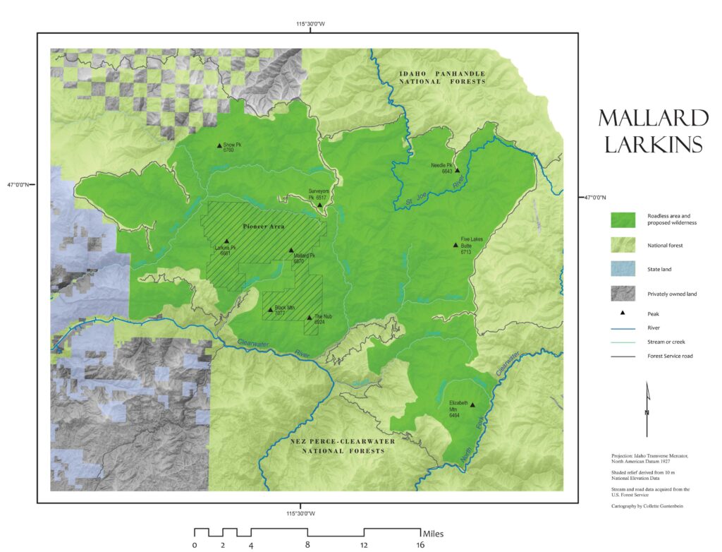
The Mallard-Larkins Roadless Area is a heavily forested 260,000-acre wildland on the divide between the North Fork of the Clearwater and the upper St. Joe rivers. The area is remote, some 50 miles northeast of Orofino and 25 miles south of Avery, Idaho. The area is bordered by Idaho State Land to the west, private and public forest to the north, NF-303 to the northeast, the Upper North Roadless Area to the east, and the North Fork of the Clearwater River (Road 250) to the south.
The Mallard-Larkins is only a few miles east of the Grandmother Mountain Roadless complex and contains the Snow Peak Wildlife Management Area.
A portion of the St. Joe River flows through the area in the northeast. In 1978, Congress designated 66 miles of the St. Joe as a Wild & Scenic River, including the portion in the roadless area. Most of the creeks of the area flow southward into the North Fork of the Clearwater River, which the USFS dropped from managing as a candidate Wild & Scenic River in 2025.
GEOLOGY
Much of the area is much older metamorphic rock, with some formations over 2.6 billion years old. “Younger” formations from 1 billion years ago include feldspathic quartzite and subordinate siltite and argillite. Some of the area is composed of batholith granites.
ECOLOGY
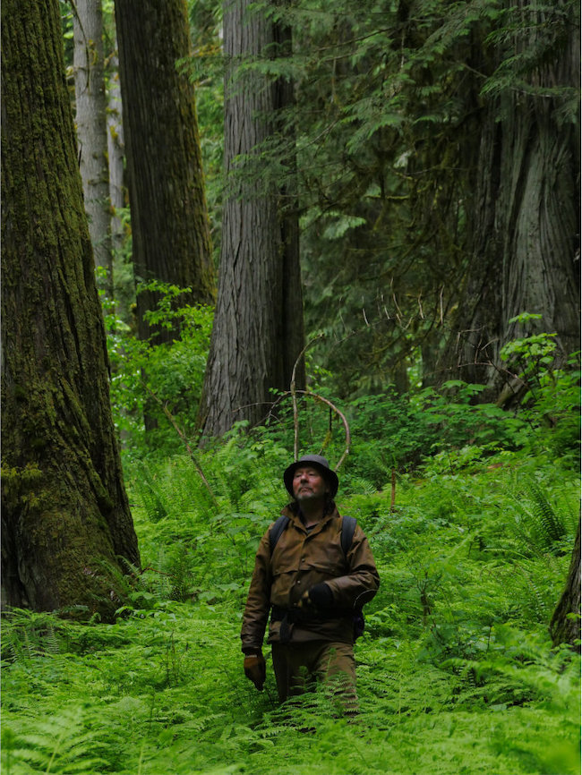
There are thirty-eight mountain lakes large enough to be named; the largest of these, at 35 acres, is Heart Lake. Although there are abundant rock outcroppings, talus slopes, and barren areas, much of the area is heavily vegetated. Plant life is extremely diverse and includes low-elevation coastal-disjunct rainforest communities and impressive pockets of old-growth western red cedar and inland Western white pine.
Near Isabella Creek, old-growth alder, Pacific yew, and many different ferns thrive among ancient cedar giants. These coastal disjuncts are leftovers from an entirely different climatic regime that survive in the rainforest-like conditions of the North Fork Canyon. Several rare and sensitive botanical varieties are also found throughout the Mallard-Larkins area.
The thirty-eight lakes lure visitors every summer. The rivers and larger streams are ideal for many species of fish, including bull trout, westslope cutthroat, and introduced Kokanee salmon.
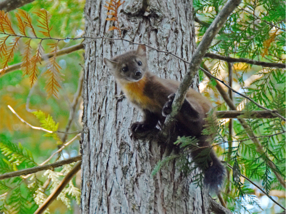
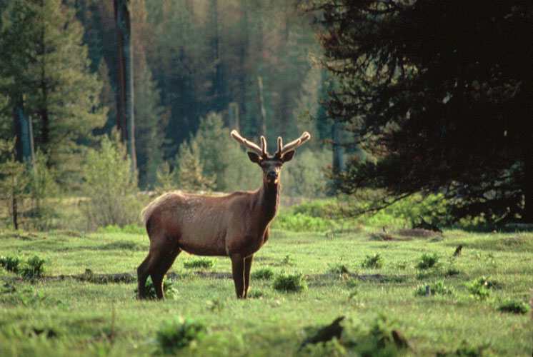
The flourishing wildlife communities range from elk, deer and moose, to black bears, mountain lions, and one of the largest populations of Mountain goats in Idaho. Mountain goats are sure-footed denizens of the high country, and very sensitive to human pressures, especially snowmobiling. These stark-white goats are also at risk from human-induced climate change.
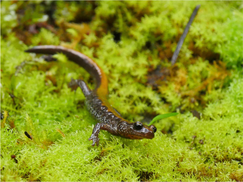
Sensitive species such as fisher, wolverine, harlequin duck, Columbia spotted frog, Coeur d’ Alene salamander, and western toad find crucial sanctuary here as well.

DWORSHAK'S SHADOW
Dworshak dam, first known as the Bruce Eddy dam, was completed in 1973. Dworshak is among the tallest dams in America at 717 feet (219 meters). The dam has had profound and lasting impacts to the Clearwater, including the Mallard-Larkins.
Dworshak is located near Ahsaka, Idaho, about 40 river miles downstream of Aquarius. Many of the possible impacts of the dam were known well before it was constructed. Public push back against the dam emphasized the loss of winter range for elk and loss of connectivity for salmon and steelhead.
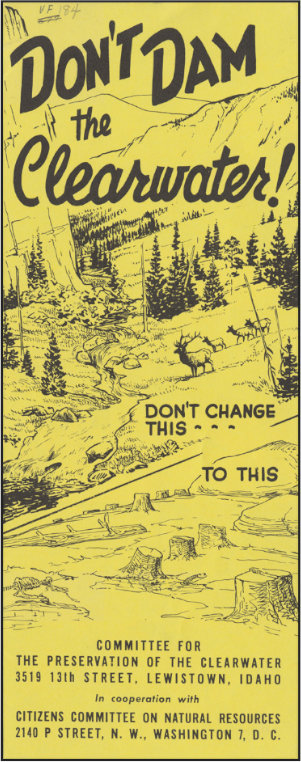
Despite some opposition, the dam was completed and extirpated one of the largest runs of salmon and steelhead in the country. Elk were likewise impacted, losing thousands of acres of winter range beneath the reservoir. The reservoir also drowned acres of Pacific disjunct cedar and red alder forest, of which the Aquarius Research Natural Area is but the small portion left.
The free-flowing North Fork of the Clearwater ends just west of the roadless area as the river reaches to slackwater of Dworshak Reservoir. The reservoir is a controversial part of landscape, as it supports invasive fish like smallmouth bass, and ended salmon and steelhead runs. However, because the water of the reservoir remains relatively cold, it is sometimes released to reduce river temperatures in the lower Snake and Columbia Rivers. Cold water is crucial for steelhead and salmon; water over 70 degrees is deadly for them.
The Mallard-Larkins area has a long history of support for wilderness protection. Already in 1969, a 30,500-acre portion of the high country characterized by abrupt summits and icy lakes was designated as the Mallard-Larkins “Pioneer Area”. Challenging and diverse terrain, blissful solitude, and humility amidst the wild landscape are readily found in this unparalleled, very special place.
Unfortunately, road-building and logging have reduced and degraded parts of the roadless area over the years, motorized vehicles have impacted the landscape, and there are proposals for mining and landscape scale prescribed burns. Ecosystem restoration is needed around the edges of the area.
Yes, it is spelled that way.

Between the Pacific Ocean and Fish Creek are 500 miles of open water. Steelhead may swim that length four times (or more) throughout their life.
It’s an important journey for them. The ocean, while full of food, isn’t a safe place to grow up. Instead, steelhead, chinook salmon, and Pacific lamprey make their way deep inland, through the Cascades, Columbia Plateau, and into the Clearwater Mountains to spawn.
The 118,000-acre Fish-Hungery Roadless Area (called the North Lochsa Slope by the Forest Service) is named for the Fish Creek watershed and it's tributary Hungery Creek. Hungery was named (and poorly spelled) by Lewis and Clark, who had turned to eating their horses in the fall of 1805 as they descended the Lolo Trail toward the Nimiipuu village of Weippe.
The region is largely the same as when Lewis and Clark saw it more than 200 years ago. The northern boundary is the Lolo Motorway, a high clearance road that closely follows a traditional Nez Perce trail and divides the Fish-Hungery area from the Weitas creek watershed. The southern boundary is US Highway 12, which follows the Wild and Scenic Lochsa River.
In recent years, calls to breach the Lower Snake River Dams have intensified, largely for the sake of anadromous (ocean-going) freshwater fish.
But even if those dams are removed, fish need quality habitat to travel to. Fish-Hungery Creek is a habitat worth protecting for them.
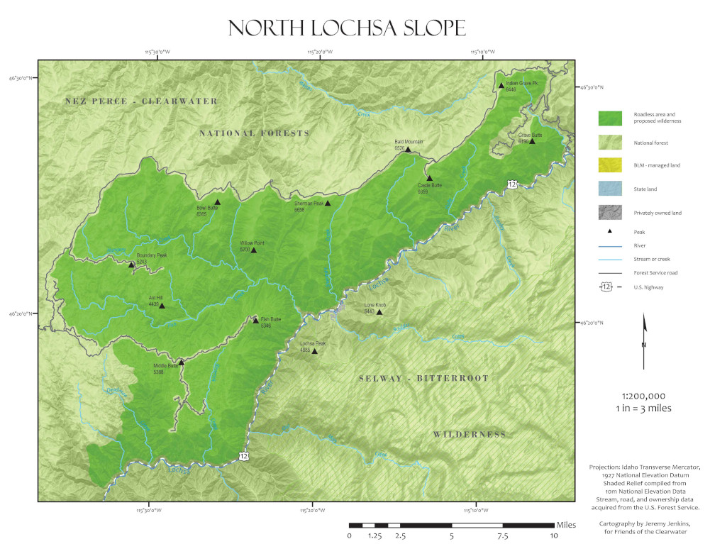
Fish-Hungery Creek is located 70 miles east of Lewiston, Idaho. It is bounded by the Lolo Motorway to the north, highway 12 to the south, and developed areas of the Clearwater National Forest to the east and West. It is part of the Clearwater Wildlands Complex, nestled between Weitas Creek, Rackliff-Gedney, and Lochsa Face Roadless Areas and the Selway-Bitteroot Wilderness Area,
Geology
This area is part of the Idaho Batholith, a vast complex of granitic rocks that vary in age from roughly 50 to 70 million years old. These granites and diorites sometimes have basalt dikes which leave long dark stripes in otherwise pale grey-pink stone.
The batholith is known for its fragility—freeze-thaw action, intense weather events, and roadbuilding cause landslides throughout the area on occasion.
Ecology
This country is characterized by two major types of drainages. One type of drainage involves a series of one- to six-mile long streams like Glade, Apgar, Deadman, and Bimerick Creeks that drain directly into the Lochsa River. The southwestern and northeastern portions of these creeks are distinguished by steep stream breaklands dissected by abrupt side drainages.
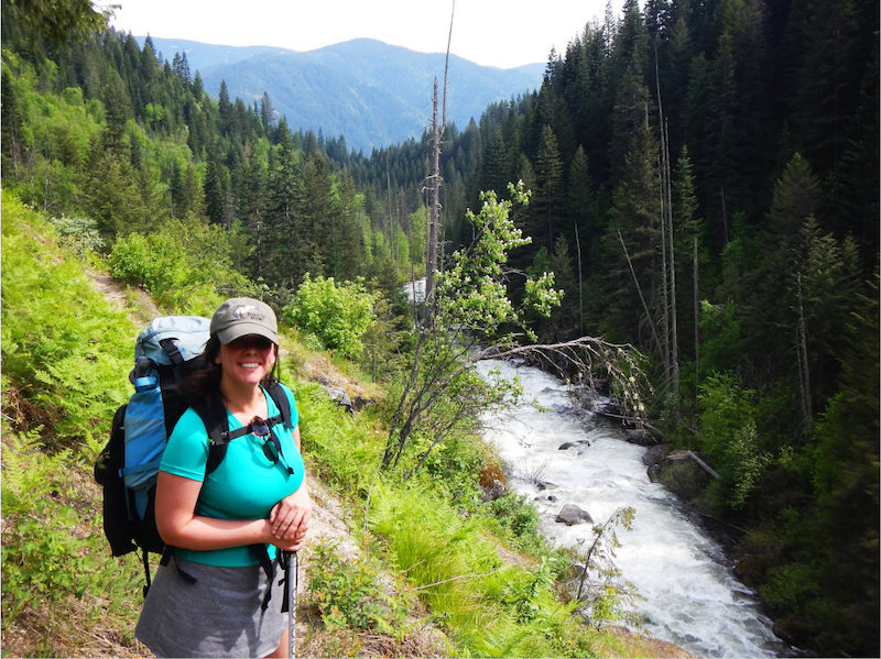
The second type of drainage, represented by the central portions of the Upper Bimerick and Fish Creek areas, exhibits a more broken topography: moderate-relief uplands and gentle hills etched with meandering streams that spill into broad, diversely vegetated bottomlands. Here, in the 60,000-acre Fish Creek drainage, the explorer is blessed with a sense of solitude and isolation from other human activity along the most important steelhead stream in Idaho. Lush, shaded banks create a vital haven for anadromous steelhead trout and Chinook summer salmon, as well as cutthroat and rainbow trout.
Elk enjoy essential summer range in the Fish Creek drainage, and the area as a whole contains nearly 18,000 acres of ungulate winter range. Mule and white-tailed deer, moose, mountain goats, cougars, black bears, fishers, pine martens, wolverines, and lynx are among the mammal denizens, and Region 1 sensitive bird and amphibian species are also present.
Elevations in the Fish-Hungery Creek area range from about 1,600 feet near the Lochsa River to over 6,500 feet atop Castle Butte to the northeast. At higher elevations, lodgepole pine, subalpine fir, and beargrass are common. Western red cedar and grand fir grace the north-facing slopes. Extensive forest fires in the early 1900s largely determined later growth. A mosaic of expansive brush fields covers many of the slopes, especially those in the southern and western portions of the area; these fields then give way to areas dense with western white pine, Douglas-fir, Engelmann spruce, larch, ponderosa pine, and mountain hemlock.

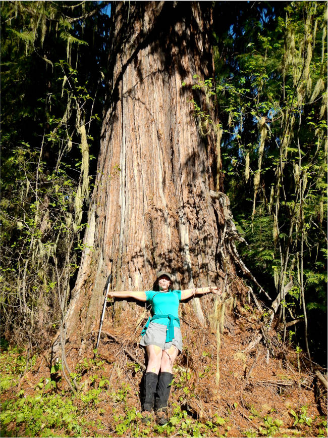
The Fish-Hungery Creek area also boasts several sensitive plant species including clustered ladyslipper, evergreen kittentail, Constance’s bittercress, broad-fruit mariposa, light hookeria, and banks monkeyflower. The 1,300-acre Lochsa Research Natural Area was established in 1977 to protect and study the unique Pacific Coast vegetation that occurs within the roadless area boundaries. Flowering dogwood and 14 other plant species not normally found east of the Cascade Mountains grow in this Research Natural Area.
An approximately quarter-mile-wide corridor along the Wild & Scenic Middle Fork/Lochsa River runs along the full length of the roadless area north of Highway 12. This 4,500-acre corridor is specially managed to emphasize the scenic values of the river's environs. A sparse network of minimally maintained trails weaves throughout the area, most constructed by the Forest Service for wildfire control access in the early 20th century. One path runs parallel to Fish Creek, offering low-impact accessibility to its cool, alluring waters.
Stream fishing, hiking, backpacking, and horseback riding are becoming more popular here; visitors can disperse widely throughout this country, from the mossy stream beds to the steep breaklands with panoramic vistas of the Selway-Bitterroot Wilderness.
The Lolo Trail is an important prehistoric route and plays a prominent role in Nez Perce culture and history. This area contains the longest remaining undisturbed section of the Lewis & Clark Trail in the country, a stretch of approximately 17 miles through the Hungery Creek drainage area.
A World War II Japanese Internment camp near Highway 12 just outside the southern boundary is one of several other noteworthy historic and prehistoric sites in or near this roadless area.
The Fish-Hungery Creek area was separated from Weitas Creek in the 1930s when the Civilian Conservation Corps constructed the Lolo Motorway. This was the primary road between Lewiston, Idaho and Missoula, Montana for decades, before the completion of US Highway 12 over Lolo Pass in 1962.
This area provides critical habitat for steelhead and became even more important after the construction of dams on the Lower Snake and North Fork Clearwater Rivers in the mid-20th century.
The Fish-Hungery Creek Roadless Area was formally identified during the RARE (Roadless Area Review and Evaluation) process during planning for the US National Forest Service's 2001 Roadless Rule. Unfortunately, the area is currently governed under the Idaho Roadless Rule, a weak piece of regulation that offers little protection from roadbuilding, logging, or other development.
Under the Clearwater National Forest Travel Plan (2012), much of the area is now open to motorcycles and ATVs and the associated disruption of natural processes and intact ecosystems. Areas to the west and east of the Fish-Hungery Creek Roadless Area have already been developed for timber harvesting. The wealth and diversity of the region’s flora and fauna cannot afford encroachment of roads and further exploitation. Its wilderness attributes and location make it an ideal wilderness candidate. However, it is not recommended in the 2025 Nez Perce-Clearwater National Forests Plan.
Weitas is almost certainly the greatest place in Idaho you have never heard of.
(NOTE: In this article, “Weitas” refers to the whole wild area, and “Weitas Creek” refers to the creek itself)
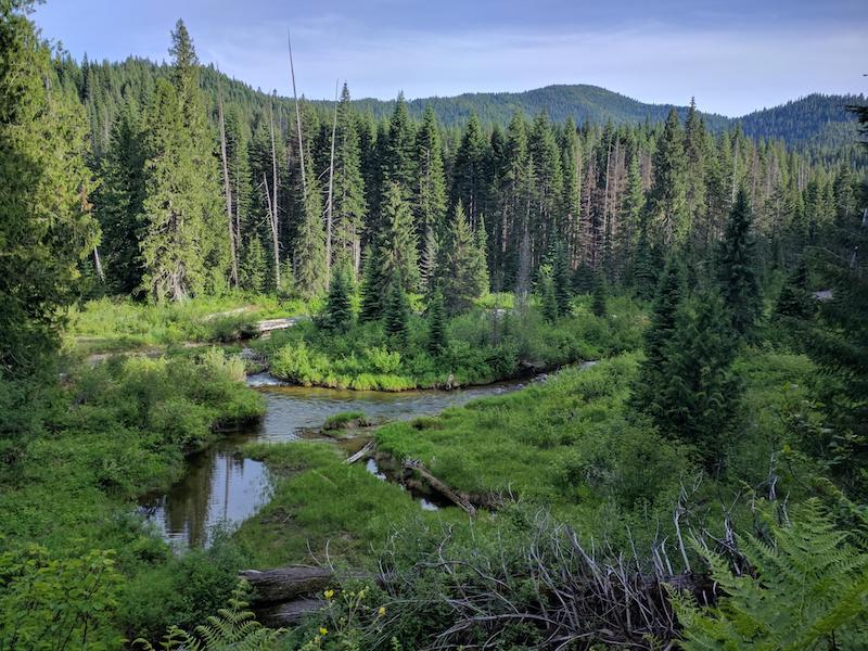
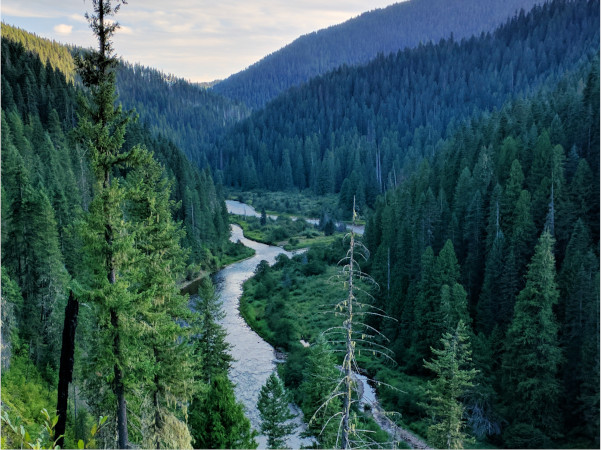
The 260,000-acre Bighorn-Weitas (pronounced “wee-tuss” or “weed-us”) Roadless Area, in the Weitas Creek and Cayuse Creek drainages, is the largest roadless area entirely within the Nez Perce-Clearwater National Forests (NPCNF), a verdant expanse of rainforest-like creek bottoms and windswept peaks. If the Wild Clearwater is the Emerald of the Rockies, Weitas is the Emerald of the Wild Clearwater.
To the Northwest, Weitas is bounded by the North Fork of the Clearwater. This section of the North Fork is free-flowing, a haven for west-slope cutthroat trout. However, it was excluded as a candidate for Wild and Scenic River designation in the 2025 Forest Plan, a reversal of the 1987 plan. Other candidate waterways include Weitas Creek itself and Cayuse Creek.
Weitas is one of the most at-risk wildlands in Idaho. This roadless area, despite its ecological importance, magnificent opportunities for solitude, and vital role as a carbon sink, is not recommended for wilderness protection by the U.S. Forest Service, nor is it protected from development under the Idaho Roadless Rule. Two bills have included Weitas or portions of it for wilderness designation, though none have passed.
Weitas is directly adjacent to five other large roadless areas, in the center of the Clearwater Wildlands Complex. It’s aptness for wilderness designation cannot be overstated.
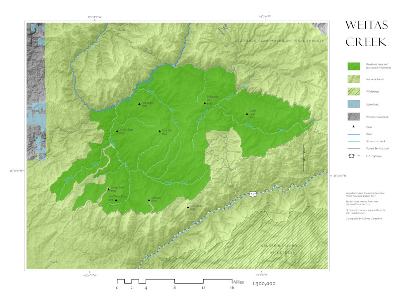
Weitas is located on the Clearwater National Forest between the North Fork of the Clearwater to the northwest, the Toboggan Ridge Road to the northeast, and the Lolo Motorway to the South. It is adjacent to six other roadless areas: Great Burn/Kelly Creek (east), Moose Mountain (northeast), Mallard-Larkins (north), Pot Mountain (northwest), Fish and Hungery Creeks (south), and Weir Creek (southeast).
Both Weitas and Cayuse creeks drain into the North Fork of the Clearwater. This section of the North Fork is free-flowing, and eventually drains into Dworshak Reservoir.
Geology
Most of the area is composed of granitic formations. Coarse-grained quartz menzonite of the Cretaceous Idaho Batholith, coupled with gneiss and rhyolite, create highly erosive soils here. However, there are few large, exposed areas of rocky and barren ground. Mountaintops are mostly rounded and deeply weathered. In some places, much older rocks over a billion years old can be found, like siltite, gneiss, and schist.
Ecology
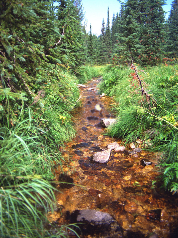
Weitas lies near the southern end of the North American inland temperate rainforest. This 600-mile-long arc of moist forests begins in eastern British Columbia and ends in north-central Idaho. Indeed, Weitas is one of the wettest places in the Gem State, receiving over 60 inches of precipitation annually.
Even in summer, the area is humid and often cloudy. Large wildfires are rare, the result of extraordinary weather events that occur every few centuries. Enormous burned cedar snags, legacies of the 1910 fires, can still be found in the area.
This wet climate supports cedar-hemlock-pine forests at low elevations (2300-4000 feet). Grand fir and western red cedar dominate in stream bottoms above understories of swordfern, wild ginger and fool’s huckleberry.
At the higher elevations, (5,000-6,500 feet) one finds spindly carex and beargrass, mountain hemlock, and even-aged lodgepole pine, their slender trunks shooting upwards in defiance of the forest fires that induced their growth.
Within conifer stands, stretch large brush fields and grass meadows create winter forage for ungulates. Roughly 18,000 acres provide crucial winter range for elk.
Wildlife abounds in this low-elevation country. Red squirrels, red-tailed chipmunks, and pygmy shrews (the smallest mammal in North America) scurry along the forest floor. Black bear are abundant, feasting on carpenter ants that inhabit rotting grand fir logs. Mule deer, moose, and mountain goats can be found here, as well as a wide variety of forest carnivores, like wolves, fisher, and northern goshawks.
Grizzly bears, though unconfirmed, may be recolonizing the area. In previous years, the U.S. Fish and Wildlife Service acknowledged the high-quality grizzly habitat in the North Fork country.
Bull trout and west-slope cutthroat trout thrive in the cold, clear streams of the area. A catch-and-release regulation was established in Cayuse Creek in 1974 for the protection and enhancement of cutthroat; Cayuse Creek has a regional reputation as an excellent fishery.
Dworshak Dam, constructed near Orofino, Idaho in 1973, entirely blocks salmon and steelhead from accessing the North Fork of the Clearwater, including the Weitas and Cayuse drainages, a serious loss to the area. However, the waterways of the Weitas area still contribute to salmon survival. In hot summers with low water, cold water from Dworshak is released into the main Clearwater to reduce temperatures downstream. This temporarily alleviates the harm caused by warm water temperatures in the slackwater, created by the dams, on migrating salmon and steelhead in the Snake and Columbia Rivers.
The Lolo Trail marks the southern boundary of the area. This trail is on both the National Historic Landmark and National Historic Trail registries. Long a fundamental prehistoric route connecting the Columbia Basin and Great Plains peoples, the trail was also traversed by Lewis & Clark.
Later, Nimiipuu leader Chief Joseph and the band of non-treaty Nez Perce traveled the trail toward Canada, attempting to escape persecution during the Nez Perce War of 1877.
In addition to this landmark, nine other prehistoric sites and fifty-seven historical sites have been located just outside, or in some cases within the region, including Forest Service lookouts, cabins, and Lewis & Clark expedition campsites, among others.
This remote area provides abundant opportunities to enjoy solitude and serenity among some of the largest intact old growth left in the entire Clearwater Basin. Opportunities for hiking, backpacking, primitive camping, horseback riding, hunting, and stream fishing are abundantly provided. Among the wide, rounded ridges of the drainages and tributaries visitors will find solitude and a sense of isolation in the verdant wild.
In 1993, much of the roadless area was included in a bill sponsored by Idaho congressman Larry LaRocco. All of Weitas Creek is included in the visionary Northern Rockies Ecosystem Protection Act, or NREPA.
Although not recommended for wilderness designation in the 1987 Clearwater National Forest plan, a 1993 settlement agreement has kept most of the area managed as potential wilderness for over 30 years. The Forest Service has suggested if this area is designated as Wilderness, the unmaintained 555 route beyond the Weitas Guard Station bridge be incorporated in the Wilderness.
Under the Clearwater National Forest Travel Plan (2012) Weitas Creek was opened to off-road motorized use, threatening to exacerbate erosion-prone soils, displace wildlife, and disturb the primitive serenity.
In the 2025 Nez Perce-Clearwater National Forests land management plan, the Bighorn-Weitas roadless area was not recommended for wilderness designation. It was only analyzed for wilderness in one alternative.
Weitas, Fourth of July, and Cayuse Creeks are ideal candidates for protection under the Wild and Scenic River Act. The North Fork of the Clearwater, though it shares many of the extraordinary values that would suggest its protection, was dropped in the 2025 plan from consideration, reducing protections in the area. The weak standards of that plan, along with misinformed efforts to log away the threat of wildfire, make the possibility of industrial logging in the Weitas area greater now than ever.
That would be an enormous loss for Idaho. As a fish and wildlife haven, a powerful carbon sink, and source of solitude, this vital place must be protected as wilderness.
At the divide of two of the wildest states in America is a vast landscape forged by fire.
The Great Burn is certainly great—over 250,000 acres of rugged Bitterroot mountains, valleys, forests, and streams only an hour from Missoula, Montana.
It’s location makes it the focal point for travel north-south along the Bitterroots, a key place for wolverines and mountain goats. Although no current breeding population is known to exist, the first grizzly bear seen in the Wild Clearwater after their local extirpation was in Kelly Creek in 2007, and the remote area remains ground zero for grizzly recovery in north-central Idaho.
The Great Burn is better known than other roadless areas we advocate for, and its easy to see why. But attention is different than protection, and attempts to reduce the size of the area and allow motorized and mechanized recreation throughout it place the area at risk.
Ultimately, it will take strong wilderness legislation, free from loopholes and exceptions, to protect this vital place.
The Great Burn/Kelly Creek Roadless Area is 255,000 acres of wild country straddling the Montana-Idaho border along the Bitterroot Divide. The divide, much of it above 6,500 feet in elevation, runs north-south for roughly 40 miles.
Over 40 fast-moving streams, large and small, drain down both sides of the ridges, mostly into Kelly Creek on the Idaho side (a tributary of the North Fork Clearwater River) and into Fish Creek on the Montana Side (a tributary of the Clark Fork).
The Great Burn is part of the Clearwater Wildlands Complex. To the west lie the upper North Fork, Moose Mountain, and Weitas Roadless areas. To the south it is bounded by the Lolo Motorway and to the southeast it is encroached by a patchwork of private and public land near US Highway 12. The northeast side is bounded by Montana State Lands, including the nearby Fish Creek State Park.
The Great Burn’s varied topography is characterized by rocky outcroppings, cliffs, and jagged peaks, with elevations that range from 3,200 feet near the mouth of Moose Creek to almost 8,000 feet atop peaks like Rhodes and Williams. The high country features impressive stands of mountain hemlock and dozens of clear lakes nestled in arena-like cirques, with colonies of low mountain heather shrubs dotting the slopes above.
The Great Burn region also contains stands of fragrant western red cedars, some over 500 years old, which shelter sensitive plants such as Mingan moonwort, banks monkeyflower, clustered lady's slipper, and Idaho strawberry. Spruce and fir dominate the Montana side; a few whitebark pines can be found above 6,000 feet.
Throughout the area, a mossy carpet of sword and maidenhair ferns is rolled out beneath the explorer’s feet. The higher ridges, especially from Williams Peak to Shale Mountain, feature craggy pinnacles and thin, irregular rocky formations often called “dinosaur rocks” for their resemblance to prehistoric creatures or "hoodoos."
Today, the Great Burn area is still favored elk-hunting country. Mule deer and black bear abound, and an estimated 20-50 mountain goats trek the rock-ribbed high country along the Bitterroot Divide. Moose, mountain lions, and many species of fur-bearers make use of this wild area’s exceptional summer range.
In 2007, a hunter killed a grizzly bear in Kelly Creek, mistaking it for a black bear. It was the first confirmed grizzly bear in the Clearwater in more than half a century. Recent research suggests that this area is essential habitat for them, as it is for lynx and several Region 1 sensitive species.

Kelly Creek and all its tributaries have been catch-and-release streams since 1970 to enhance Westslope cutthroat trout populations. Twelve- to fifteen-inch fish are not uncommon, lending national recognition to the drainage. Most of the larger streams and lakes support cutthroat and rainbow trout (steelhead have been landlocked since the construction of Dworshak Reservoir). Fish Lake, threatened by potential off-road vehicle use, is important habitat for bull trout.
Kelly Creek Roadless Area is a critical biological link between the massive Selway-Bitterroot Wilderness to the south and the Greater Cabinet-Yaak ecosystem to the north. Full protection of this regional wildland is essential in order to curb damaging snowmobile and off-road vehicle use on the Idaho side and to prevent speculative mining ventures.
INDIGENOUS HISTORY
An archaeological site in Kelly Creek contains some of the oldest evidence of humans in Idaho, dating back perhaps 12,000 years BP. The site is notable for the presence of artifacts that originated outside of northern Idaho, supporting evidence of large-scale trade networks among Indigenous people throughout the continent.
The Kelly Creek region is located near the edge of traditional Schi̲tsu'umsh (Coeur d'Alene) and Nimiipuu (Nez Perce) traditional territories and has, for the last several hundred years, been important to both of these groups well as the Salish peoples of present-day Montana. At the southern end of the area, the Lolo Trail carries deep cultural and historic significance.

1910 FIRES
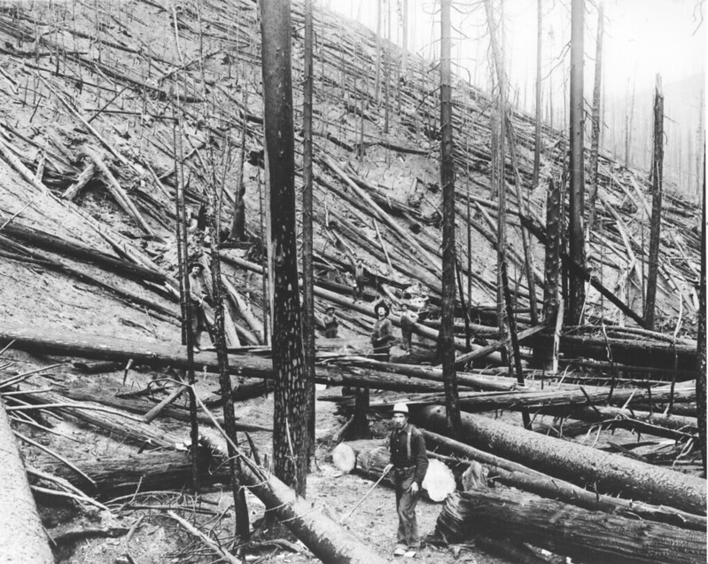
Whether called the Great Burn, Great Fires, or Big Blow-Up, the fires of 1910 played a significant role in shaping the region and the history of American forests.
At the time, loggers still relied on handsaws and horses. In northern Idaho, industrial forestry was just beginning, bringing steam donkeys, coal-fired trains, and working men by the thousands to the forests. First on the chopping block were easy-to-reach old-growth forests. The upper Clearwater basin was mountainous, remote, and (at least partly) publicly owned - not the easiest place for timber giants like Weyerhauser and Potlatch to log. Contemporary accounts by the nascent United States Geological Survey and Forest Service describe a landscape of virtually unending green.
However, green expanses don't preclude fire. In 1910, after a record dry spring and blazing summer, lightning strikes started dozens of fires throughout the region, from eastern Washington through Idaho to Western Montana. In August, a windstorm fanned the flames into a firestorm of unimaginable intensity all across the region.
The scale of that fire is difficult to convey due to its sheer size and speed. In just three days, an estimated 3 million acres of forests burned. In comparison, 2018's Camp Fire, which destroyed Paradise, California and burned the Plumas National Forest, claimed about 150,000 acres in two weeks. the Great Burn was thus twenty times as large and burned six times faster.

There are two lasting legacies of the fire, one administrative and one ecological.
Administratively, the fires caused an about-face. Due to the sheer magnitude of the event and the human loss of life, the US Forest Service re-oriented itself from one of protecting forests from exploitation to one of protecting timber resources from fire. The history is well documented in the books Year of the Fires by Stephen Pyne and The Big Burn by Timothy Egan.
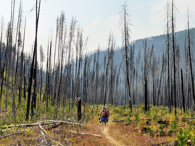
Ecologically, the 1910 fires offer us a glimpse into wildfire regimes prior to forestry in the Northern Rockies. The 1910 fires were an extremely rare, natural, weather phenomena, the confluence of high temperatures, low humidity, lightning strikes, and strong winds. Such events may only happen once every thousand years in the Bitterroots, but evidently they occurred prior to logging, prior to fire suppression, and prior to human-caused climate change.
The legacy of the fires reverberates today. Some areas remain treeless, instead persisting as brush fields or expanses of wildflowers. Local elk populations ballooned mid-century, in part due to the massive increase in grazing and foraging habitat. Timber production still remains scant in the surrounding area due to the loss of much forest cover in early 20th century fires.

Due to the 1993 Forest Plan lawsuit settlement agreement, this area has been spared roadbuilding and logging impacts, though logging is proposed just adjacent to the area. It is one of a few places that has been protected from logging in the Forest Service's 2008 Idaho Roadless Rule.
That said, the Forest Service did not stop motorized use on one trail that accesses Fish Lake, an area the Forest Service recommended for Wilderness in the original Clearwater National Forest Plan. This action endangered the rare bull trout population in the lake via an increase in anglers, even though the Forest Plan provisions to protect wildlife habitat required the agency to close the trail to motorized use. FOC and allies went to court, twice, and won.
However, the Forest Service failed to address what the court had ordered it to do in the first lawsuit. In the second lawsuit, the court required the Forest Service to close the Fish Lake Trail. The trail is closed until 2025, when the new Forest Plan takes effect. In that new plan, the Forest Service eviscerated the wilderness recommendation on the Great Burn, leaving out Fish lake. Much of the area will now be the domaine of motorized and mechanized use.

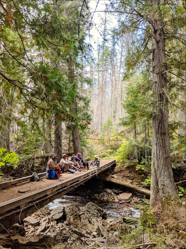
The Place
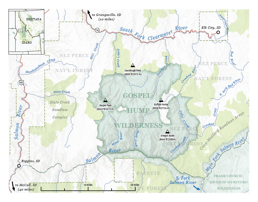
In a state as wild as Idaho, even designated Wilderness areas can be overlooked. The Gospel-Hump Wilderness is the overlooked middle child of Idaho wildernesses, located just to the west of the (much more well-known) Selway-Bitterroot and Frank Church-River of No Return. The Gospel Hump lies on the divide between the Clearwater and Salmon drainages, roughly 20 miles southeast of Grangeville, Idaho.
Overlooked doesn't mean undeserving. This 200,000-acre wilderness area embodies the rugged beauty of two very different ecoregions in Idaho.
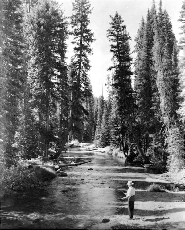
The northern portion of the Wilderness is moist and heavily forested country, green with grand fir, Englemann spruce, and Pacific yew in its wetter locations. Numerous fresh-water streams and sub-alpine lakes flow south into the South Fork Clearwater, including high-quality fisheries like John's Creek.
The southern portion is steep and sparsely vegetated, particularly along the Salmon River Breaks. This is dry country, blazing hot in summer and bitingly cold in winter. The often treeless hillsides support bunchgrass, prickly pear cactus, and curl-leaf mountain mahogany. High winds, dry conditions, and frequent summer storms make this region subject to relatively frequent fires that ascend the canyon walls with astonishing speed.
The northern and southern areas are separated by a rugged, glaciated divide, which contains the peaks for which the Wilderness is named, Gospel Hill and Buffalo Hump.
History
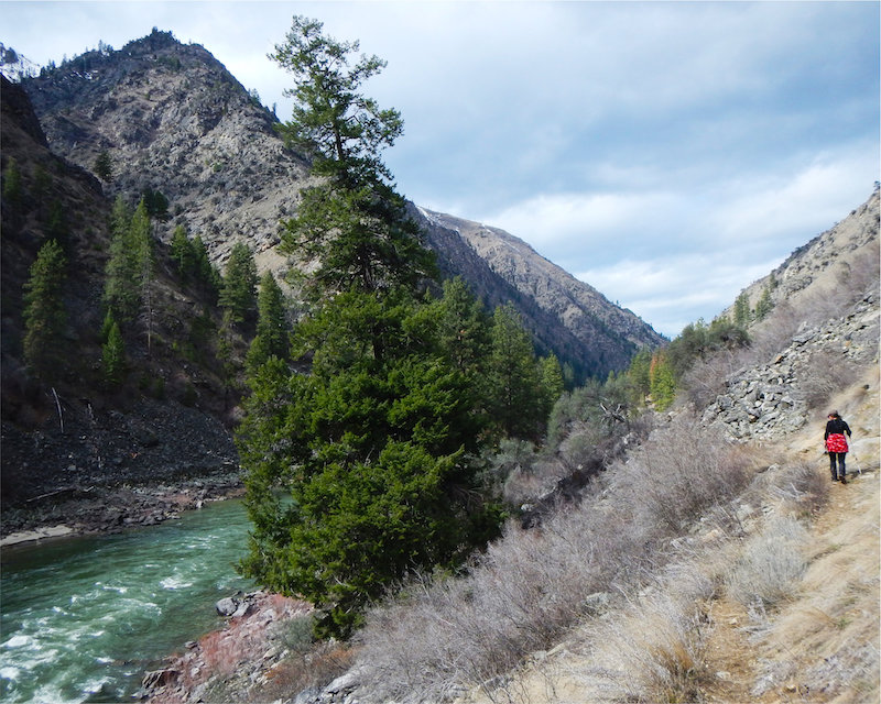
The United States Congress designated the Gospel-Hump Wilderness in 1978 under the Endangered American Wilderness Act. The Selway-Bitterroot Wilderness is located to the northeast of this area, and the Frank Church-River of No Return Wilderness lies just to its south and east. The entire southern boundary of the Gospel-Hump Wilderness runs along the Wild & Scenic Main Fork of the Salmon River. The area has a total of 205,796 acres and is managed by the Forest Service.
Elevations range from 1,970 feet at the Wind River pack bridge on the Salmon River to 8,940 feet at the summit of Buffalo Hump. Weather patterns vary by location and can be quite unpredictable. Temperatures can soar to 100 degrees Fahrenheit along the Salmon River, while rain and snow often falls in the high country. Moose, mountain goats, bighorn sheep, mountain lions, wolves, and anadromous fish all make their home here. Wild steelhead and Chinook salmon still make their annual migration up the Main Fork of the Salmon.
Seasonal roads of fair-to-poor quality surround the Wilderness, and are often impassable due to late snows. Some of these roads offer access to trails that lead from the Salmon River Breaks into the high country, which many hikers would classify as very challenging. Some choose to head southeast from Grangeville, while others access the area from the South Fork of the Clearwater drainage to the north.
Management
There is much room for improvement in the stewardship of the Gospel-Hump Wilderness. Unlike in the Selway-Bitterroot Wilderness, domestic livestock graze the Gospel-Hump Wilderness. If the Forest Service retired these grazing allotments as soon as possible, further damage to soils and riparian areas could be prevented. Motorized recreation has also been reported inside the Wilderness, a blatant and unacceptable violation of the Wilderness Act of 1964. A robust wilderness-character monitoring effort could substantiate and quantify impacts from grazing and off-road vehicle and snowmobile trespass so actions could be taken to address those impacts. Jet-boating activity on the Main Fork of the Salmon River also disrupts what would otherwise be a profoundly primitive experience.
The Gospel-Hump Wilderness is contiguous to the Frank Church-River of No Return Wilderness. If the area were managed as a single unit, as is done with the Bob Marshall Complex in Montana, adequate funding and attention for this Wilderness area could be better ensured.
Wildlife
The northern portion of the wilderness (and the roadless areas adjacent to it) are ideal habitat for the fisher, a large relative of the weasel. Fishers are rare in the Clearwater due to logging and trapping, and could warrant protection under the Endangered Species Act.
The Big Wild
It's easy to describe the Frank Church-River of No Return, but difficult to do so without superlatives. Words like biggest, wildest, ruggedest, remotest. The River of No Return (also called "The Frank") is one enormous rectangular-ish block of wild country, the largest contiguous wilderness outside Alaska (Death Valley Wilderness is larger, but broken into smaller sections by roads). It protects the unruly Middle Fork of the Salmon River watershed as well as portions of adjacent watersheds.
This wilderness is 2.36 million acres, most of which is in Central Idaho. This doesn't include unprotected roadless country adjacent to it, nor the Gospel-Hump Wilderness, separated only by the Main Salmon. All together, this wildlands complex is about 3.25 million acres (5,000 square miles), or just a little smaller than Connecticut (a state of 3.6 million people).
And yet, even in the center of this wilderness you are little more than 17 miles away from the closest road as the crow flies. Just to show how small our biggest wildernesses are.
Only a portion of the Frank is north of the main Salmon River, administered by the Bitterroot National Forest and Nez Perce National Forest. That portion includes Bargamin Creek as well as the headwaters of the Selway River. Friends of the Clearwater is most focused on this section, as it is directly adjacent to or part of the Clearwater.
The Frank is actually only separated from the Selway-Bitterroot Wilderness by one dirt road, the Magruder Corridor, which runs from Elk City, Idaho to the Bitterroot Valley near Darby, Montana, and is loosely overlays the southern Nez Perce Trail.
Landscape
Geologically, most of the area is part of the Idaho Batholith, an extensive . The northern edge of the River of No Return is an ecological transitional area. North Idaho, as the southern end of the inland wetbelt forests, tends to be lower in elevation, wetter in precipitation, and host more developed soils than the Salmon River country.

The Place
The Selway-Bitterroot Wilderness (SBW, or just Selway) is one of the great achievements of conservation in the United States. At more than 1.3 million acres, this wilderness area protects most of the Selway River basin in Idaho and the high Bitterroot mountains in Montana.
The Selway is one of the original wildernesses designated by Congress under the 1964 Wilderness Act and was expanded in the 1980 Central Idaho Wilderness Act. Only the Southern Nez Perce Trail (the Magruder Corridor), an unimproved dirt road, separates the Selway-Bitterroot from the even larger Frank Church-River of No Return Wilderness to the South. Together, they would constitute the largest protected wild place in America outside Alaska.

The size of this wild area is matched only by its stunning diversity. The northwestern border of the wilderness abuts the Lochsa River, just 1800 feet (550 m) above sea level. This part of the Wilderness is wet and lush, supporting coastal disjunct species like Western red cedar and some of the only inland populations of Pacific dogwood. Visitors can camp at the Wilderness Gateway Campground on US Highway 12 to experience the Lochsa River and Selway-Bitterroot Wilderness.
At the southwestern edge of the wilderness careens Selway Falls. Here, at the right time of year, visitors can see migrating steelhead and chinook salmon leap above the whitewater as they make their way to their natal streams. The entire Selway River is protected under the Wild and Scenic Rivers Act; fish can swim its roughly 100 river miles without encountering a dam.
The further upriver you travel, the higher you climb. The headwaters of the Selway lie in the High Bitterroots: 9,000-foot (2600 m) granite peaks on the Idaho-Montana state line. Just to the east of this ridge in Montana is Trapper Peak (10,157 ft/3096 m), the highest point in the Bitterroots. These granite towers are steep, cold, and windy, too extreme for most trees. Wind-bent whitebark pine live here, providing nuts for Clark's nutcrackers.
During the Last Glacial Maximum, valley glaciers gouged out this whole area, leaving enormous U-shaped valleys not unlike those in Glacier National Park. These mountains are best seen and accessed from Highway 93 in Montana, where they form a massive palisade running north-south for nearly 50 miles, starting near Lolo and ending near Connor.
In between the hot, wet Selway canyon and the snow-bound, craggy Bitterroot crest is enough wild country to get lost in for a lifetime - and abundant great habitat for wildlife.
Wildlife
Diverse habitats support diverse wildlife. The lower Selway provides winter range for many ungulates and year-round habitat for moose, wolves, black bears, fishers, wolves, and possibly grizzly bears. Steelhead and salmon still make their way up the Wild and Scenic Selway River as they have done for millennia. In summer, harlequin ducks fly inland from the coast to nest along the fast-running streams. The avid birder may also see osprey, bald eagles, mergansers, spotted sandpipers, dippers, and kingfishers in the river canyon.

The high peaks of the SBW offer refuge for wolverines, snowshoe hares, mountain goats, and lynx. Recent studies indicate that the Bitterroot crest would make for top-tier denning habitat for grizzly bears, which are moving into the area. The cold mountain streams of the Bitterroots are ideal for Westslope cutthroat and Bull trout.
History
The Selway is an important place to the Nimiipuu, who have used the area for centuries. Trails 206 and 664, for example, closely follow one ancient trail that the Nimiipuu navigated on their travels between Clearwater Country and the Great Plains of present-day Montana along the Selway Crags.
The southern Nez Perce Trail, also used for reaching Montana, became the basis of today's Magruder corridor, the southern border of the Wilderness. South of that dirt road is the Frank Church-River of No Return Wilderness.

Management and Threats
The Selway features many hiking trails as well as some remote spots without maintained paths. During the main floating season, the Forest Service allows just one party per day to launch non-motorized boats on the Selway River — a very popular trip.
Fires are mostly allowed to play their natural role, especially in the Idaho portion of the wilderness. Indeed, the Selway-Bitterroot was the first place where managers intentionally allowed a lightning strike to burn into a fire and go out on its own in the early 1970s.
However, the wilderness character of this area is harmed by overbuilt trails and Forest Service structures and sites, including landing strips in meadows, such as at Fish Lake. The Idaho Fish & Game Department also exerts political pressure on the Forest Service to promote highly manipulative game management rather than a wilderness-protection management mentality.
Unprotected Wildlands
Several roadless areas directly adjacent to the Selway-Bitterroot could be added to the designated wilderness. Together they add up to about 580,000 acres of unprotected wilderness. These include the following in Idaho:
Two potential additions are primarily in Montana:
The Bitterroot Face is currently at risk of development. Nearly all of that roadless area is targeted for logging and road-building under the Bitterroot Front Project on the Bitterroot National Forest.
The Nez Perce and Clearwater National Forests have been under the same management plans since 1987. Very soon, they may be managed under a combined new plan that would strip or weaken many protections for wildlife and habitat.
One purpose of the National Forest Management Act (NFMA), passed by Congress in 1976, was to address the growing controversial practice of clearcutting on U.S. national forests. Clearcut logging involves removing all or most trees over a given stand, to be sold as timber. The practice inflicts significant damage to the other resources found in natural forest ecosystems. NFMA limited the size of clearcuts on most national forests in the western U.S. to 40 acres, but the law also contained loopholes.
In recent years Friends of the Clearwater noticed a growing trend in national forests of the Northern Region exploiting NFMA’s clearcutting loopholes. Our staff investigated and prepared a report in 2021.
Our report revealed a drastic increase of requests from Forest Supervisors to the Regional Forester, who is authorized to approve such exceptions to the 40-acre limit. Total acres of these “supersized clearcuts” in the Northern Region averaged less than 10,000 acres annually from 2013-2018, but ballooned to exceed 32,000 acres in 2020. We found not a single instance of a request being denied by Regional Forester Leanne Marten.
Read the embedded report below, or scroll to the bottom of the page to download the PDF.
The-Clearcut-Kings_USFS-Northern-Region-and-Obsession-w-Supersized-Clearcuts-2021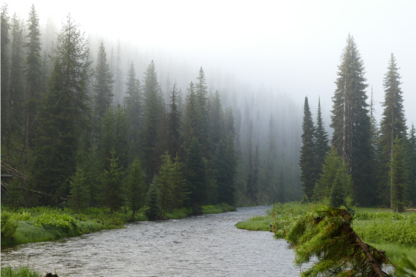
During the Clinton administration, public outcry over logging wildlands on national forests was amplified by campaigns such as Cove-Mallard in the Nez Perce National Forest. These actions rallied citizens from around the country to conduct direct action in protest of massive roadbuilding and clearcutting of roadless areas. Such publicity resulted in the Clinton administration proposing a nationwide regulation to limit exploitation of these remaining unprotected wildlands. The resulting 2001 Roadless Area Conservation Rule was touted as a major victory by many conservation groups.
In 2020, Friends of the Clearwater completed an investigation into the effectiveness of the 2001 rule—and another crafted in 2008 to apply to national forest lands within the state of Idaho—to preserve wilderness character of roadless areas.
Virtually unknown to the general public, we found the exceptions written into these rules were being exploited by the U.S. Forest Service, authorizing the development of roughly 39,000 acres of wild roadless areas in Montana and 18,000 acres in Idaho. Mostly this happened because loopholes allow industrial activities promoted as “habitat restoration”—a justification of logging by the Forest Service that has become ubiquitous. Use of these loopholes has accelerated since 2010.

In 2022, the House of Representatives passed a package of bills that would have codified the 2001, Idaho, and Colorado Roadless Rules as law. Because of the complete lack of knowledge of the problems of these rules on the ground, many in the conservation community saw this as a step forward. Luckily, the omnibus bill did not pass the Senate, and the roadless rules (and the loopholes they contain) are not federal law.
To permanently protect roadless areas, Friends of the Clearwater supports legislation that would close the loopholes of the various roadless rules and set a higher standard for their protection. FOC also supports a bill that would protect roadless country in our region that has been introduced into Congress several times: The Northern Rockies Ecosystem Protection Act (NREPA). Among other important provisions, NREPA protects as Wilderness essentially all the roadless areas in the Nez Perce-Clearwater National Forests and most other roadless areas in the bioregion defined by that proposal. You can learn more here.
Read the entire report below, or download the PDF a the bottom of the page.
Bilodeau-Macfarline-THE-ROADLESS-REPORT-FINAL-with-addendum-update-Sept.-2020Friends of the Clearwater
PO Box 9241
Moscow, ID 83843
(208) 882-9755